100% FREE ACCESS
10th Standard Syllabus & Materials
10th Standard
TN 10th English Prose - 4 - The Attic Important Questions And Answers Study Material - QB365 Set A
NEW10th Standard
TN 10th English Supplementary - 3 - The Story of Mulan Important Questions And Answers Study Material - QB365 Set A
NEW10th Standard
TN 10th English Poem - 3 - I am Every Woman Important Questions And Answers Study Material - QB365 Set A
NEW10th Standard
TN 10th English Prose - 3 - Empowered Women Navigating The World Important Questions And Answers Study Material - QB365 Set A
NEW10th Standard
TN 10th English Supplementary - 2 - Zigzag Important Questions And Answers Study Material - QB365 Set A
NEW10th Standard
TN 10th English Poem - 2 - The Grumble Family Important Questions And Answers Study Material - QB365 Set A

Published on: 05/08/2019
India - Location, Relief and Drainage
Download Tamil Nadu 10th Standard Social Science question papers, model tests, one-mark questions, important questions, and public exam papers in PDF format. Free study materials and answer keys for TN State Board students.
Questions + Answers key
Take MCQ Social Science Test
1.
The ____________ river divides the plateau region of India broadly into two parts.
Kaveri
Narmada
Tapti
Mahanadi
2.
The highest point in Trans Himalayas is _______.
Mt. Godwin Austen (K2)
Kanchenjunga
Anai Mudi
Mahendra Giri
3.
Earth rotates from ___________ to ___________
South to north
East to west
West to east
North to south
4.
The Palk Strait and Gulf of Mannar separates India from ______.
Goa
West Bengal
Sri Lanka
Maldives
5.
The north-south extent of India is
2,500 km
2,933 km
3,214 km
2,814 km
6.
River Padma
7.
Meghna river
8.
Sambar lake
9.
Yamuna
10.
Tsangpo
11.
Write a note on Delta plains.
12.
Write a note on purvanchal hills.
13.
Write the longitudinal and latitudinal extent of India.
14.
Write a brief note on the island group of Lakshadweep.
15.
State the west following rivers of India.
16.
17.
Describe peninsular plateau.
18.
Write the importance of Himalayas.
19.
Give a detailed account on the basin of the Ganga.
20.
Explain the divisions of Northern Mountains and its importance to India.
21.
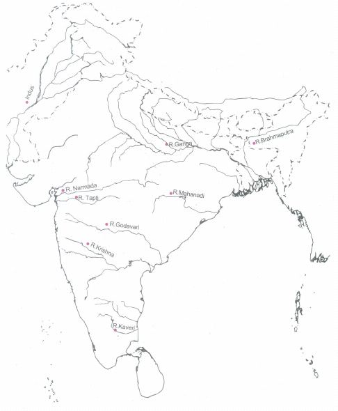
Mark the following in the outline map of India
Major rivers – Indus, Ganga, Brahmaputra, Narmada, Tapti, Mahanadi, Godavari, Krishna & Kaveri.
1.
(b)
Narmada
2.
(a)
Mt. Godwin Austen (K2)
3.
(c)
West to east
4.
(c)
Sri Lanka
5.
(c)
3,214 km
6.
Bangladesh
7.
River Brahmaputra
8.
Rajasthan
9.
Tributary of River Ganga
10.
River Brahmaputra in Tibet
11.
(i) The deltaic plain is an extension of the Khadar land. It covers about 1.9 lakh sq.km in the lower reaches of the Ganga River.
(ii) It is an area of deposition as the river flows in this tract sluggishly.
(iii) The deltaic plain consists mainly of old mud, new mud, and marsh.
(iv) In the delta region, the uplands are called 'Chars' while the marshy areas are called 'Bils'.
12.
(i) These are the eastern off-shoot of Himalayas. It extended in the north-eastern states of India. Most of these hills are located along the border of India and Myanmar while others are inside India.
(ii) Dafla Hills, Abor Hills, Mishmi Hills, Patkai Bum Hills, Naga Hills, Manipur Hills, Mizo Hills, Tripura Hills, Mikir Hills, Garo Hills, and Khasi Hills are the hills which are collectively known as purvanchal hills.
13.
India extends from 8° 04' N to 37° 06' N latitudes and between 68° 07' E to 97° 25' E longitudes.
14.
i) This is a small group of coral islands located off the west coast of India. It covers an area of 32 sq. km.
ii) Lakshadweep islands are separated from the Maldive islands by the Eight Degree Channel.
iii) The uninhabited Pitts island of this group has a bird sanctuary.
iv) Kavaratti is its administrative capital.
15.
Narmada, Tapti, Mahi and Sabarmathi are the west following rivers of India.
16.
17.
(i) The plateau region lies to the south of the Great Northern Plains. This is the largest physiographic division of our country.
(ii) It covers an area of about 16 lakh sq.km (about half of the total area of the country). It is an old rocky plateau region.
(iii) Aravalli hills mark the north-western boundary of the plateau region.
(iv) Its northern and north-eastern boundaries are marked by the Bundelkhand upland, Kaimur and Rajmahal hills.
(v) The Western Ghats and the Eastern Ghats mark the western and eastern boundaries respectively.
(vi) The peak of Anaimudi is the highest point in the plateau. Its height is 2,695 m and is located in Anaimalai.
(vii) River Narmada divides the plateau region of India broadly into 2 parts.
(viii) The region lying to the north of the Narmada is called the Central Highlands and the region lying to the south of Narmada is called the Deccan Plateau.
(ix) All the major rivers (Mahanadi, Godavari, Krishna, Kaveri, etc.) lying to the south of the Vindhyas flow eastwards and fall into the Bay of Bengal.
(x) Narmada and Tapti are the two rivers situated to the south of the Vindhyas flow westward.
(xi) Their movement towards west is due to the presence of a rift valley in the region.
18.
(i) Himalayas blocks southwest monsoon winds and causes heavy rainfall to north India.
(ii) It forms a natural barrier to the subcontinent.
(iii) It is the source for many perennial rivers like Indus, Ganges, Brahmaputra, etc.
(iv) The Northern Mountains are described as the paradise of tourists due to its natural beauty.
(v) Many hill stations and pilgrim centers like Amarnath, Kedarnath, Badrinath, and Vaishnavi Devi temples are situated here.
(vi) It provides raw material for many forest based industries.
(vii) It prevents the cold winds blowing from the central Asia and protects India from severe cold.
(viii) Himalayas are renowned for the rich biodiversity.
19.
i) The river Ganga originates as Bhagirathi from the Gangotri Glacier in Uttar Khasi district of Uttarakhand state.
ii) The length of the river Ganga is about 2,525 km.
iii) Its major tributaries from the north are Gomti, Gandak, Kosi and Ghaghara.
iv) Its tributaries from south are Yamuna, Son and Chambal. The largest of its tributaries is the Yamuna.
v) The Ganga river system is the largest drainage system in India. It extends over an area of 8,61,404 sq km in India.
vi)The Ganga plain is the most densely populated place in India.
vii) The river Ganga is known as the River Padma in Bangladesh.
viii) The combined river of Ganga and Brahmaputra creates the World's largest delta known as Sundarbans in Bangladesh before joining the Bay of Bengal.
20.
Divisions of Northern Mountains are:
1) The Trans Himalayas
2) The Himalayas
3) Eastern Himalayas or Purvanchal Hills.
The Trans Himalayas
i) The Trans Himalayas lies to the north of great Himalayan range. It lies in Jammu and Kashmir and Tibetan plateau. The trans Himalayas are about 40 km in its eastern and western extremities and about 225 km wide in its central part.
ii) They contain the Tethys sediments. The rocks of this region contains fossils bearing marine sediments which are underlain by Tertiary granites. It has partly metamorphosed sediments and constitutes the core of the Himalayan axis.
The Himalayas
i) It constitutes the core part of northern mountains. It is an young fold mountain. It was formed by the movement of Eurasia land mass in the north and Gondwana land mass in the south.
ii) It consists of many ranges.
The main divisions of the Himalayas are the
i) The Greater Himalayas (The Himadri)
ii) The Lesser Himalayas (The Himachal)
ii) The Outer Himalayas (The Siwalik's)
The eastern or Purvanchal Hills
i) These are the eastern off shoot of Himalayas. It extended in the north eastern states of India.
ii) Most of these hills are located along the border of India and Myanmar while others are inside India.
Importance of Himalayas:
i) Himalayas blocks southwest monsoon winds and causes heavy rainfall to north India.
ii) It forms a natural barrier to the sub-continent.
iii) It is the source for many perennial rivers like Indus, Ganges, Brahmaputra, etc.
iv) The Northern Mountains are described as the paradise of tourists due to its natural beauty.
v) Many hill stations and pilgrim centers like Amarnath, Kedarnath, Badrinath and Vaishnavi devi temples are situated here.
vi) It provides raw materials for many forest based industries.
vii) It prevents cold winds blowing from the central Asia and protects India from severe cold.
viii) Himalayas are renowned for the rich bio-diversity.
21.

10th Standard Syllabus & Materials
10th Standard
TN 10th English Prose - 2 - The Night the Ghost Got in Important Questions And Answers Study Material - QB365 Set A
NEW10th Standard
TN 10th English Supplementary - 1 - The Tempest Important Questions And Answers Study Material - QB365 Set A
NEW10th Standard
TN 10th English Poem - 1 - Life Important Questions And Answers Study Material - QB365 Set A
NEW10th Standard
TN 10th English Prose - 1 - His First Flight Important Questions And Answers Study Material - QB365 Set A



Tamilnadu Stateboard 10th Standard Subjects
Tamilnadu Stateboard Standards