100% FREE ACCESS
6th Standard Syllabus & Materials
6th Standard
TN 6th Tamil பருவம் 1 - இயல் 1 - மொழி -தமிழ்த்தேன் - இன்பத்தமிழ் Sample Question Papers Study Material - QB365 Set A
NEW6th Standard
TN 6th English T1 - Supplementary - The Apple Tree and The Farmer Sample Question Papers Study Material - QB365 Set A
NEW6th Standard
TN 6th English T1 - Prose - When The Trees Walked Sample Question Papers Study Material - QB365 Set A
NEW6th Standard
TN 6th Social Science T3 - CIV - Road Safety Sample Question Papers Study Material - QB365 Set A
NEW6th Standard
TN 6th Social Science T3 - CIV - Local Bodies - Rural and Urban Sample Question Papers Study Material - QB365 Set A
NEW6th Standard
TN 6th Social Science T3 - CIV - Democracy Sample Question Papers Study Material - QB365 Set A

Published on: 05/09/2026
Download Tamil Nadu 6th Standard Social Science question papers, model tests, one-mark questions, important questions, and public exam papers in PDF format. Free study materials and answer keys for TN State Board students.
Questions + Answers key
Take MCQ Social Science Test
1.
The western and north-western Europe enjoys mild and humid climate. Choose the correct option:
These regions are found near the equator
It is influenced by the North Atlantic Drift
It is surrounded by mountains
All of the above
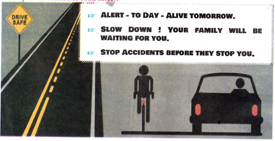
2.
The Intermontane ________________ plateau is found between Elbruz and Zagros.
Tibet
Iran
Deccan
The Yunnan
3.
The total number of lines of latitude are
171
161
181
191
4.
Which of the following lines of longitude is considered for the Indian Standard Time?
82½° E
82½° W
81½° E
81½° W
5.
_______is National Panchayat Raj Day
January 24
July 24
November 24
April 24
6.
The Kantara School of Sanskrit flourished in the _________ during 2nd century BC.
Deccan
north-west India
Punjab
Gangetic valley
7.
____________is celebrated as the International Democracy Day.
September 15
October 15
November 15
December 15
8.
The birth place of democracy is_____________
China
America
Greece
Rome
9.
The lowest unit of administration during the Sangam Age was______________
Mandalam
Nadu
Ur
Pattinam
10.
The rule of Pandyas was followed by _______
Satavahanas
Cholas
Kalabhras
Pallavas
11.
People choose their representatives by giving their _________
12.
Direct Democracy is practised in _________.
13.
The Panchayat Raj Act was enacted in the year_______
14.
The density of population in Europe is__________
15.
The important fishing ground in North Sea is________
16.
The national dance of Philippines is_________
17.
The Prime Meridian is also called ______________
18.
_________ was the founder of Indo-Parthian Kingdom.
19.
____________ built Kallanai across the river Kaveri.
20.
The battle of Venni was won by ____________________.
21.
What are fjords? How do they protect harbours from bad weather conditions?
22.
How are the hemispheres divided on the basis of lines of latitude and longitude? Explain with diagrams.
23.
What is flood? Explain the do’s and don’ts during floods.
24.
Draw posters related to road safety
25.
Local bodies play an important role in the development of villages and cities. How?
26.
Provide an account of trade and commerce during the post-Mauryan period in South India.
27.
Compare and contrast direct democracy and representative democracy.
28.
Karikal Valavan is regarded as the greatest Chola king. Justify.
29.
Name the ports found is Asia.
30.
How does physiography play a vital role in determining the population of Asia?
31.
Name the four hemispheres of the Earth.
32.
How many times would the sun pass overhead a line of longitude?
33.
Differentiate: Landslide – Avalanche
34.
Chennai, Cuddalore and Cauvery delta are frequently affected by floods. Give reason.
35.
Identify the following signs
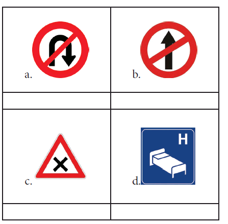
36.
What is the importance of Grama Sabha?
37.
What are the divisions of a rural local body?
38.
What are the salient features of our constitution that you have understood?
39.
Define: Direct Democracy
40.
The North western highlands and the Alpine mountain range.
41.
Tundra and Taiga.
42.
Cold desert and hot desert.
43.
Intermontane plateaus and southern plateaus.
1.
(b)
It is influenced by the North Atlantic Drift
2.
(b)
Iran
3.
(c)
181
4.
(a)
82½° E
5.
(d)
April 24
6.
(a)
Deccan
7.
(a)
September 15
8.
(c)
Greece
9.
(c)
Ur
10.
(c)
Kalabhras
11.
()
votes or elections.
12.
()
Switzerland
13.
()
1992
14.
()
34 persons/Km2
15.
()
Dogger bank
16.
()
Tinikline.
17.
()
Greenwich Meridian
18.
()
Gondophernas
19.
()
Karikalan
20.
()
Karikalavallavan (or) Karikalan
21.
Fjord:
1. A fjord is a narrow and deep sea inlet between steep cliffs.
2. It reduces the speed of wind irrespective of its direction and protect harbour.
3. The force of sea waves are also controlled.
4. Fjords are best situated for natural harbours.
22.
Northern Hemisphere:
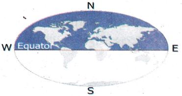
The area of the Earth found. between the Equator [0o] and the North pole [90o] is called the Northern Hemisphere.
Southern Hemisphere:
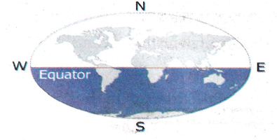
The area of the Earth from the equator to the South pole [90oS] is called the Southern Hemisphere.
Eastern Hemisphere:
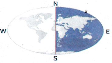
The part of the Earth between the 0o line of longitude and the 180o East line of longitude is known as the Eastern Hemisphere.
Western Hemisphere:
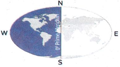
The part of the Earth from 0o line of longitude to 180o West line of longitude is called as Western Hemisphere.
23.
Flood:
An overflow of a large amount of water, beyond its normal limits, especially on the rain fed areas is called a flood.
Do's during flood:
(i) Cut off gas connection and electricity.
(ii) Leave immediately through the prescribed.
(iii) Drink hot water.
Don'ts:
(i) Try to connect electricity once it is cut.
(ii) Operate vehicles.
(iii) Swim against floods.
(iv) Avoid going on excursions.
(v) Neglect flood warning messages.
24.
25.
Local bodies play an important role in the development of villages and cities, because there are many services provided by local bodies to the people like drinking water supply, street lighting, Drainage and sewage pipe system, Laying down roads and maintenance, laying public parks, libraries, play grounds, etc. The main work of local bodies is activation of central and state government schemes to the common people.
26.
(i) The break-up of Mauryan Empire resulted in the invasion of Sakas, Scythians, Parthians, Indo-Greeks of Bactrain Greeks and Kilshanas from the north-west.
(ii) The most important features of the Post - Mauryan period was the growth of trade and commerce, both internally as well as externally.
(iii) These were two major internal land routes in ancient India, ie, Uttarapatha and Dakshinapatha.
(iv) The important ports on the western coasts were Sopara and Broach. On easten coast were Arikamedu and Kaveripattinam.
(v) The trade between India and Rome flourished during this period.
(vi) There was constant trade in silk between India and China.
(vii) The Kushanas and the Satvahanas especially benefited from their trade with the Roman Empire.
(viii) India forged trade relations with Java, Sumatra, Malaysia, Burma and China also.
27.
| S.No | DIRECT DEMOCRACY | REPRESENTATIVE DEMOCRACY |
| 1. | In a direct democracy, only the citizens can make laws. | Elected members only can make laws. |
| 2. | All changes have to be approved by the citizen. |
Council of legislative changes the laws. |
| 3. | The politicians only rule over parliamentary procedure. |
Members of parliament rule the country. |
28.
(i) Karikalvalavan or Karikalan was the most famous of the chola kings.
(ii) He defeated the combined army of the cheras, Pandyas and the eleven velir chieftains who supported them at Venni, a small village in the Thanjavur region.
(iii) He converted forests into cultivable lands. He built kallanai across the river Kaveri to develop agriculture.
(iv) Their port puhar attracted merchants from various regions of the Indian Ocean.
(v) The Pattinapaalai, a poetic work in the Pathinenkeezhkanakku, gives elaborate information of the trading activity during the rule of karikalan.
29.
Tokyo, Shanghai, Singapore, Hong Kong, Chennai, Mumbai, Karachi and Dubai are the important seaports in Asia.
30.
(i) The population is unevenly distributed because of various physical features.
(ii) River plains and industrial regions have high density of population, whereas low density is found in the interior parts of Asia.
31.
(i) Northern hemisphere
(ii) Southern hemisphere
(iii) Eastern hemisphere
(iv) Western hemisphere
32.
The Sun is overhead on a line of longitude only once in a day.
33.
| Landslide | Avalanches |
| The movement of a mass of rocks, debris, soil etc., down slope is celled landslide. | A large amount of ice, snow and rock falling quickly down the side of a mountain is called an Avalanches. |
34.
(i) Due to heavy rainfall from North east Monsoon.
(ii) Inefficient engineering design in the construction of embankments, dams, and canals
(iii) Did not follow some important safety precautions.
35.

36.
(i) It is the only permanent unit in the panchayat Raj system
(ii) The Grama Sabha is the grass root level democratic institution in a Village Panchayat.
(iii) Grama Sabha meetings are conducted four times in a year. Officers like District collector, the block development officer, teachers, etc. also participate in this meeting.
(iv) The people can freely express their needs and grievances.
37.
The rural local bodies are categorised into Village Panchayats, Panchayat Unions and District Panchyats.
38.
(i) The structure of the government institutions and methods the rules and regulations to be followed and the powers and responsibilities.
(ii) It fixes the Rights and Duties and the Directive Principles of the citizens.
39.
(i) When the people themselves directly express their will on public affairs the type of government is called pure or direct democracy.
(ii) Ex: Switzerland.
40.
| S.No | The North western highlands | The Alpine mountain range |
| 1. | Region includes the mountains and plateaus of Norway, Sweden, Finland, Scotland and Iceland. | The alpine mountain system consists of a chain of young fold mountains found in the southern part.of Europe. |
| 2. | This region has the most beautiful fjord coast. | Eg: It lies Sierra Wevada, Pyrenees, Kaskasas are important mountains. |
41.
| S.No | Tundra | Taiga |
| 1. | The Arctic and northern Scandinavian highland have Tundra type of vegetation made up of lichens and mosses. | Coniferous or Taiga vegetations are found to the south of the Tundra region in Norway, Sweden, Finland, Germany, Poland and Austria. |
| 2. | Lichens and mosses are the important tree varieties of Tundra forest. |
Pine, fir, spruce and larch are the important tree varieties of taiga forest. |
42.
| S.No | Cold desert | Hot desert |
| 1. | The cold desert has ice and the snow in the ground. |
The hot desert is battered by a high sunrays. |
| 2. | The temperature of cold deserts is low. | The temperature of the hot deserts is high. |
43.
| S.No | Intermontane plateaus | Southern plateaus |
| 1. | Intermontane plateaus are wide tablelands that are formed or situated between mountain ranges, when a plateau is surrounded by mountains on all sides, it is refers to an Intermontane plateaus | The southern plateaus are relatively lower than the northern plateaus. |
| 2. | Eg: Tibetan Plateau, Bolivian plateaus. | The four important southern plateaus are the Arabian Plateau, Deccan Plateau, Shan Plateau and the Yunnan Plateau. |

6th Standard Syllabus & Materials
6th Standard
TN 6th Social Science T3 - GEO - Globe Sample Question Papers Study Material - QB365 Set A
NEW6th Standard
TN 6th Social Science T3 - GEO - Asia and Europe Sample Question Papers Study Material - QB365 Set A
NEW6th Standard
TN 6th Social Science T3 - HIS - South Indian Kingdoms Sample Question Papers Study Material - QB365 Set A



Tamilnadu Stateboard 6th Standard Subjects
Tamilnadu Stateboard Standards