100% FREE ACCESS
6th Standard CBSE Syllabus & Materials
6th Standard CBSE
CBSE 6th Social Science The Value of Work - New Sample Question Papers Study Material - QB365 Set A
NEW6th Standard CBSE
CBSE 6th Social Science Family and Community - New Sample Question Papers Study Material - QB365 Set A
NEW6th Standard CBSE
CBSE 6th Social Science India's Cultural Roots - New Sample Question Papers Study Material - QB365 Set A
NEW6th Standard CBSE
CBSE 6th Social Science India,That is Bharat - New Sample Question Papers Study Material - QB365 Set A
NEW6th Standard CBSE
CBSE 6th Social Science Timeline and sources of history - New Sample Question Papers Study Material - QB365 Set A
NEW6th Standard CBSE
CBSE 6th Social Science Oceans and Continents - New Sample Question Papers Study Material - QB365 Set A

Published on: 24/10/2025
Download CBSE Class 6th Standard CBSE Social Science question papers, sample papers, important questions, and previous year solved papers in PDF format. Get free study materials, NCERT solutions, and exam preparation resources for Class 6th Standard CBSE Social Science
Questions + Answers key
Take MCQ Social Science Test
1.
What do the following colours represent on map?
2.
Why do we need to understand maps?
3.
What are the main components of a map? How do they help us?
4.
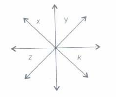
In the following diagram, which arrow indicates the East North direction.
5.
Look at the given figure and answer the following questions.
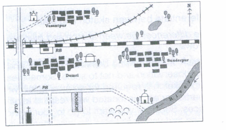
(i) In which direction is the river flowing?
(ii) What kind of road passes by the side of village Dumri?
(iii) On what type of railway line is Sunderpur situated?
(iv) On which side of the railway bridge is the police station situated?
(v) On which side of the railway line do the following lie:
(a) Chhatri
(b) Church
(c) Pond
(d) Mosque
(e) River
(f) Post and Telegraph Office
(g) Graveyard
6.
Differentiate between sketch and plan.
7.
Describe the components of maps and their importance?
8.
Define maps and its various types?
9.
A map is a representation or a drawing of the Earth's surface or a part of it drawn on a flat surface according to a scale.
(i) Why is the use of symbols important in the drawing of map?
(ii) What are the components of a map?
10.
How do physical maps show the elevations of features?
11.
Mention some of the disadvantages of magnetic compass.
12.
There is a scale. It may be used for measuring distance between places. For example, the distance between the well and the tree is 5 cm. It means that the actual distance is 50 metres. Now the distance between the PO (A) to Karim's house (E) is 12 cm. It means 120 metres on the ground but you cannot fly like a bird directly from E to A. You will have to walk on the road. Let us measure the total walking distance from E to C, then C to M, M to B and B to A. Add all these distances. This will be the total walking distance from Karim's house to the Post Office.
1.
Blue-lakes, rivers, streams, oceans, reservoirs, etc.
Red-major highways, roads, urban areas, airports, special interest sites, military sites, place names, buildings, borders.
Yellow-built-up or urban areas.
Green-parks, golf courses, forest, orchards, highways.
Brown-deserts, historical sites, national park", military reservations or bases, contour (elevation) lines.
Black-railways, highways, bridges, place names, buildings, borders.
2.
We need to understand maps because of the following reason :
(i) To find our way around a city.
(ii) To find the location of specific places in a new city.
(iii) To find the shortest route to a specific spot.
(iv) To find out locations of petrol pumps, police station and rest houses on highways.
(v) In case of emergency, it helps to find the nearest hospital or medical aid.
3.
The components of maps are:
(i) Symbols: Symbols are used on maps because it is not possible to show all details of an area as they actually are. These symbols make it easier to draw maps and also, to understand them.
(ii) Direction: There are four main directions i.e. East, West, South and North, known as the cardinal directions. Maps easily help us to locate direction on the given surface, because northern direction of a map is always marked as 'N'.
(iii) Distance: With the help of scale, large areas can be shown on a small scale map.
4.
x
5.
(i) The river is flowing in the South-East direction.
(ii) Metalled road is passing by the side of village Dumri.
(iii) Sunderpur is situated on broad gauge railway line.
(iv) Police station is situated on the South side of the railway bridge.
(v) (a) South
(b) South
(c) North
(d) North
(e) South
(f) South
(g) South
6.
The differences between sketch and plan are as follows:
Sketch It is a drawing based on memory and spot observation and not to scale. Sometimes, a rough sketch is required for an area to tell, where a particular area is located with respect to other places. Suppose you want to go to your friend's house and you don't know the way, then your friend may make a rough sketch to show the way to his house. Such a rough drawing is called a sketch map.
Plan: Plan of an area consists of details about length and breadth of a particular location. A plan is a drawing of small area on a large scale or in other words, a drawing drawn to scale is called plan.
7.
There are three components of maps:
(i) Distance A small distance on paper represents a large distance on the ground through a scale.
(ii) Direction Most maps contain an arrow marked with the letter 'N' at the upper right hand corner. This shows the North direction. By knowing one direction, other directions can be found out.
(iii) Symbol: Symbol is the third important component of a map. It is impossible to draw exact size of different features such as buildings, roads, bridges, trees, railway lines or a well on a map, so they are shown by using certain letters, shades, colours, pictures and lines.
8.
A map is a representation or drawing of the earth's surface or a part of its area drawn on a flat surface according to a scale. There are different types of maps.
Some of them are as follows:
(i) Physical maps Maps showing natural features of the earth such as mountains, plateaus, plains, rivers, oceans etc are called physical or relief maps.
(ii) Political maps Maps showing cities, towns, villages and different countries and states of the world with their boundaries are called political maps.
(iii) Thematic maps Maps with specific information like road maps, rainfall maps, maps showing distribution of forests, industries etc are known as thematic maps.
9.
(i) Maps can be easily drawn with the help of symbols like colours, letters, shades, pictures, etc. Symbols represent different features like buildings, roads, bridges, trees, railway lines, temples, etc. and also, make it easier to read the maps.
(ii) The three components of map are-distance, direction and symbol.
10.
Physical maps commonly use colours most dramatically to show changes in elevations. A palette of green is often used to display common elevations. Dark green usually represents low-lying land white lighter green used for higher elevations. For higher elevations, physical maps will often use light brown to dark brown.
11.
The compass is very stable in areas close to the Equator, which is far from "Magnetic North". At some point close to the Magnetic Pole, the compass will not indicate any particular direction, but will begin to drift in a non-direction indicating manner. Also, the needle starts to point up or down when getting closer to the poles, due to the so called magnetic inclination. Cheap compass with bad bearings may get stuck due to this, thereby indicating a wrong direction.
12.
Let the distance from E to C = 5 cm.
C to M = 3 cm.
M to B = 2 cm.
B to A = 2 cm.
The total walking distance between Karim's house and post office is the sum of all distances, i.e.
(E to C) + (C to M) + (M to B) + (B to A)
5 + 3 + 2 + 2 = 12 cm.
Therefore according to the scale
1 cm = 10 m. 12 cm = 120 m.

6th Standard CBSE Syllabus & Materials
6th Standard CBSE
CBSE 6th Social Science Locating Places on the Earth - New Sample Question Papers Study Material - QB365 Set A
NEW6th Standard CBSE
CBSE 6th Science A Journey Through States of Water - New Sample Question Papers Study Material - QB365 Set A
NEW6th Standard CBSE
CBSE 6th Science Temperature and its Measurement - New Sample Question Papers Study Material - QB365 Set A
NEW6th Standard CBSE
CBSE 6th Science Materials Around Us - New Sample Question Papers Study Material - QB365 Set A



NCERT Books

Syllabus

Exam Pattern

Sample Question Papers

Previous year Question Papers

Important Notes

MCQ Practice test

NCERT Exemplers

Case study Questions

Image Based Questions

Passage based Questions

HOT Questions

Value Based Questions

Model Questions Papers
NCERT ( Book Back ) Questions

Assertion and Reason
Important Questions And Answers

CBSE 6th Standard CBSE Subjects
CBSE Standards