100% FREE ACCESS
6th Standard CBSE Syllabus & Materials
6th Standard CBSE
CBSE 6th Social Science The Value of Work - New Sample Question Papers Study Material - QB365 Set A
NEW6th Standard CBSE
CBSE 6th Social Science Family and Community - New Sample Question Papers Study Material - QB365 Set A
NEW6th Standard CBSE
CBSE 6th Social Science India's Cultural Roots - New Sample Question Papers Study Material - QB365 Set A
NEW6th Standard CBSE
CBSE 6th Social Science India,That is Bharat - New Sample Question Papers Study Material - QB365 Set A
NEW6th Standard CBSE
CBSE 6th Social Science Timeline and sources of history - New Sample Question Papers Study Material - QB365 Set A
NEW6th Standard CBSE
CBSE 6th Social Science Oceans and Continents - New Sample Question Papers Study Material - QB365 Set A

Published on: 06/03/2020
6th Standard CBSE Social science Annual Exam Model Question 2020
Download CBSE Class 6th Standard CBSE Social Science question papers, sample papers, important questions, and previous year solved papers in PDF format. Get free study materials, NCERT solutions, and exam preparation resources for Class 6th Standard CBSE Social Science
Questions + Answers key
Take MCQ Social Science Test
1.
What do you understand by democracy? What did Gandhiji say about right to vote in his journal 'Young India'?
2.
What are the functions of a Patwari ?
3.
What do you understand by 'zamindari system?
4.
Explain briefly the caste system in India.
5.
Distinguish between Eastern Coastal Plains and Western Coastal Plains.
6.
Differentiate between Solstice and Equinox.
7.
How are the members of the Lok Sabha elected?
8.
What was the method used in ancient times by the people to determine direction?
9.
Why is Kerala called the 'land of coconuts'? What products are made out of coir in Kerala?
10.
The local time at the longitude 821/2° E is taken as the Standard Time for the whole country of India. It is known as Indian Standard Time (IST).
(i) What is the importance of IST?
(ii) What time zone is India in?
11.
What were the sources of raw materials for the Harappans?
12.
Which period witnessed environmental changes like the melting of glaciers and their replacement by thick forests ? What else do you know about this period ?
13.
Mention some of the opinions given by the people against Varna system
14.
Explain the administrative system adopted by the kings of the earlier times.
15.
Write about the administration of Ashoka
16.
This is a picture of a sack full of grains. Answer the following questions related to the picture:
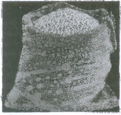
(i) In what ways were grains used?
(ii) How did the early man store grains?
(iii) How did farming affect the life of the early man?
17.
Why is the city of Arikamedu historically important?
18.
Why did Gangabai go to the Councillor's house? What did he suggest?
19.
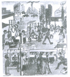
What do you see in this illustration?
20.
What are the types of mountains?
21.
Describe the composition of a Village Panchayat.
22.
Give the details of following main continents:
(i) Asia (ii) Africa
(iii) North America (iv) South America
23.
Answer the questions based on picture given below:
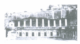
(i) Where is the Jaina monastery in the picture situated?
(ii) What were the rooms of the building used for?
24.
Define maps and its various types?
25.
Discuss the different types of seasons found in India.
26.
What were the silent sentinels behind the story of the megaliths?
27.
'Each of these pilgrims left an account of his journey'. Discuss.
28.
Answer the questions based on the picture given below:
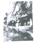

(i) The cave above in the picture are located in which state?
(ii) What was the purpose of these caves?
29.
Answer the questions based on the picture given below:
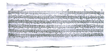
(i) How many years ago this manuscript was written?
(ii) How were books made from palm leaves?
(iii) What type of manuscripts is shown in the picture?
30.
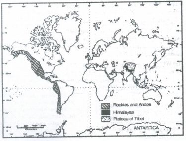
On an outline map of the world, mark the following:
(i) Mountain ranges: Himalayas, Rockies and Andes.
(ii) Plateau Tibet
31.
Show the following cities on the outline map of India
(i) Rakhi Garhi
(ii) Sotkakoh
(iii) Kalibangan
(iv) Mohenjodaro
(v) Lothal
32.
On the outline map of the world, mark the following?
Europe, Asia, Antarctica, South America, Australia, Indian Ocean, Pacific ocean, Atlantic ocean and Ural mountains.
33.
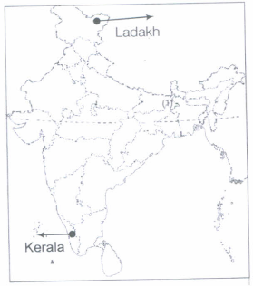
Look at the map of India in an Atlas and locate Kerala and Ladakh. Can you list three ways in which the different geographical location of these two regions would influence the following?
(i) The food people eat
(ii) The clothes they wear
(iii) The work they do.
34.
Mark the following important cities and kingdoms on the outline map of India:
(i) Thanesar (ii) Ujjain (iii) Pataliputra
35.
On an outline map of India, mark the following
(a) Tropic of Cancer
(b) Standard Meridian of India
(c) Andaman Islands and Lakshadweep Islands
(d) Western Ghat and Eastern Ghats.
36.
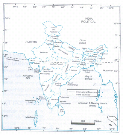
Find the state in which you live in the political map on page 136. Were there any janapada in your state? If yes, name them.
If not, name the janapadas that would have been the closest to your state, and mention whether they
were to the East, West, North or South.
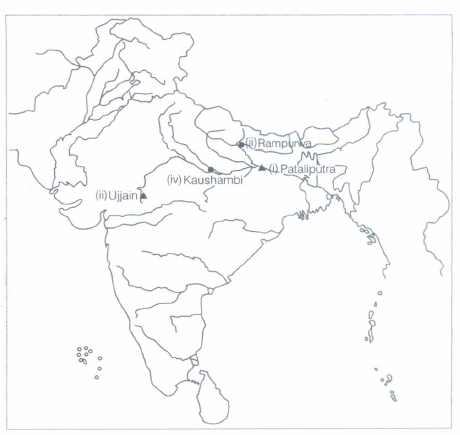
37.
Mark the following places on the outline map of India:
(i) Pataliputra
(ii) Ujjain
(iii) Rampurwa
(iv) Kaushambi
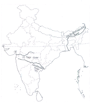
38.
Locate the following of the outline physical map of India.
(i) Tapi river
(ii) Brahmaputra river
(iii) Godavari river
39.
What-are the main problems faced by vendors?
40.
What are the drawbacks of cutting trees?
41.
Why do you think that agricultural labourers (like Muniamma) are forced to accept low wages?
42.
What are the discriminations faced by the Dalits in India even today?
43.
How has Suez Canal affected the trade and commerce of India in the world?
44.
What will happen if the Earth does not rotate?
45.
"Unity in diversity was the source of strength in India during the British rule". In this context, answer the given questions. How did the Indians with diverse backgrounds show their strength during the struggle for independence?
46.
Why is Mercury the hottest planet in the Solar System?
47.
What do you mean by Thematic Maps?
48.
What is the importance of latitudes?
49.
Why did the Harappan houses look a like?
50.
Why did kings want to control the Silk Route? How did traders benefit out of it?
51.
Discuss why it is important to study our past.
52.
Who were the people who composed the hymns?
53.
What is a Sangha?
54.
How are complicated decisions taken?
55.
Other Public Services-A survey
This chapter has looked at some of the administrative work of the government. especially for rural areas. The first example related to maintaining law and order and the second to maintaining land records. In the first case we examined the role of the police and in the second that of the Patwari.
This work is supervised by other people in the department, such as the Tehsildar or the Superintendent of Police. We have also seen how people these services and some of the problems that they face. These services have to be used and made to function according to the laws that have been framed for them.
You have probably seen many other public services and facilities provided by various departments of the government.
Do the following exercise for your village/by visiting a nearby village or looking at your own area. List the public services in the village/area such as : the milk society, the fair price shop, the bank, the police station. the agricultural society for seeds and fertiliser, the post office or sub post office, the anganwadi, creche, government school/s, health centre or government hospital etc.
Collect information on three public services and discuss with your teacher how improvements can be made in their functioning. One example has been worked out.
56.
What are the causes of destruction of natural resources?
57.
Was there a problem with the BPL list that the Gram Sabha was finalising? What was this problem?
58.
What are the four major domains of the earth?
59.
List five ways in which the non-whites were discriminated against.
60.
Do you think it was a true democracy?
61.
Try and list as many uses of paper as you can.
62.
Why do you think the government needs to make rules for everyone in the form of laws?
63.
Name a famous man who taught in Prakrit and a king who issued inscriptions in Prakrit.
64.
List the crafts persons who would have been present in both villages and cities.
65.
In what ways do you think Ashoka's attitude towards neighbouring peoples was different from that of the Chinese emperors?
66.
Why do archaeologists think that many people who lived in Mehrgarh were hunters to start with and that herding became more important later?
67.
What tools would you use today for cutting fruit? What would they be made of?
68.
The chapter mentions two types of government:
Dictator ship and democracy
Democracy and monarchy
Democracy and partial democracy
Dictatorship and monarchy
69.
What is the main crop of the village Kalpattu
Paddy
Wheat
Sweet corn
Sugarcane
70.
Which is the smallest continent in the world?
Australia
Europe
North America
Africa
71.
'Apartheid' is :
Racial segregation on the basis of race and colour
the name of a South African dish
the traditional dance of South Africa
the traditional dress of South Africa
72.
Map showing cities, towns and village of the world with their boundaries is called:
Political map
Physical map
Thematic map
None of these
73.
In earlier cities, the part to the west was smaller but higher and was called:
Citadel
Lower town
Upper town
Non of these
74.
Great Qing was a pilgrim from:
Rome
Greece
China
Somalia
75.
Northern Black Polished ware is a type of:
Pottery
Stamp
Footwear
Cloth
76.
Which crop was first grown to the North of the Vindhyas?
Wheat
Rubber
Sugarcane
Rice
77.
Which river(s) was/were worshipped as goddesses?
Beas
Sutlej
Both (a) and (b)
None of these
78.
Who was Aryabhata?
A politician
An astronomer
A teacher
A writer
79.
The uncollected garbage attracts dogs, rats and flies, so we should
cover them.
keep them open.
throw them on to the roads.
throw them here and there.
80.
Where does Nirmala work?
In an export garment unit
In a ticket booking centre
In Sudha's office
In a market street
81.
A district is divided into which part?
Taluka
State
Tehsil
Both 'a' and 'c'
82.
Which one of the following is not popular sport in mountains?
Paragliding
River Rafting
Sailing
Skiing
83.
Who tells that we should conserve water and refill it?
Tijia
Anwar
Birju
Natwar
84.
Which of the following regions is located in the South-West corner of India?
Ladakh
Tamil Nadu
Kerala
Punjab
85.
Who was the companion of raja in the battlefield?
Men
Charioteer
Raja
Brahmin
86.
What would happen if monsoons were weak, or even worse, failed to occur one year?
Crop will be___________
Affected
Not Affected
87.
Who was the founder of Gupta dynasty?
Chandragupta
Samudragupta
Shrigupta
Skandagupta
88.
What is the local time of longitude that has been taken as the Indian Standard Time?
82°30'E
23°30'N
68°7'E
97°25'E
89.
The movement of the Earth around the sun is known as
Rotation
Revolution
inclination
90.
Who is known as the father of Constitution of India
Pt. Jawaharlal Nehru
Dr. BR Ambedkar
Dr. Rajendra Prasad
Dr. Shyama Prasad Mukherjee
91.
The Frigid zone lies near
the poles
the equator
the tropic of Cancer
92.
At what speed does light travel?
300,000 km/sec
400,000 km/sec
200,000 km/sec
100,000 km/sec
93.
At present, where the Rampurwa bull has been placed?
Bihar Bhavan Bhavan
Rashtrapati
Parliament
India Gate
94.
Which of the following was the earliest domesticated animals?
Cow and ox
Sheep and goat
Horse and buffalo
Buffalo and cow
95.
From which Vedic group, Buddha belonged to?
Brahman
Kshatriya
Shudra
Vaishya
96.
Traces of ash have been found in
Hunsgi
Mumbai
Kurnool
Bhimbetka
1.
A democratic government can be understood as a representative government where people elect their representatives through periodic elections. These representatives in turn, meet and make decisions to serve the interests of the entire population. A democratic government allows universal adult
franchise to its citizens.
However, in their earliest forms, governments allowed only men to vote. Poor people and women were exempted from this right. In this context, Gandhiji, in his journal 'Young India', rejected this idea. He held that it is not fair to extend the right to vote only to the wealthy lot. He advocated that men of good character and also poors should also be given the right to vote because poverty is not a crime.
2.
(i) The Patwari is responsible for measuring lands and keeping land records in villages.
(ii) The Patwari is responsible for organising the collection of land revenues from the farmers and providing information to the government about the crops grown in the area.
(iii) The Patwari is the kingpin of the land record system in the villages.
3.
Zamindar was an official employed by the Mughals to collect taxes from peasants. The practice was continued under the British rule. The Zamindar was considered as the landlord and he would collect all taxes on his lands and then hand over the collected taxes to the British authorities. The Zamindars exploited the tillers and took for themselves a major share of the produce and the peasant was left with very little. Thus, they had to borrow money from the Zamindars and in return, they served them as bonded labour till the debt was repaid. After independence, the Government of India abolished both the systems
4.
India has a hierarchical caste system in the society. The Indian term for caste is 'jati', which generally designates a group varying in size from a handful to many thousands. There are thousands of such jatis and each has its distinctive rules and customs. Varna (meaning, "colour") refers to the ancient and somewhat ideal fourfold division of the Hindu society: (1) the Brahmins-the priestly and learned class; (2) the Kshatriyas-the warriors and rulers; (3) the Vaisyas- farmers and merchants; and (4) the Shudras, peasants and laborers. The caste system was born and maintained by the Brahmins, the priestly class and they are the ones to get more advantage from it.
5.
| S.No. | Eastern Coastal Plains | Western Coastal Plains |
| (i) | They are broad | They are narrow |
| (ii) | They are directed by a number of rivers | They have two main rivers. |
| (iii) | The rivers form deltas | The rivers form estuaries |
| (iv) | They lie between the Bay of Bengal and Eastern Ghats | They lie between the Arabian Sea and Western Ghats |
6.
The difference between Solstice and Equinox are given below:
| S.No | Solstice | Equinox |
| (i) (ii) (iii) |
It is dependent on the sunrays falling on the tropics. When the rays fall vertically on the tropics, days and nights are either longer or shorter. There is summer solstice or winter. |
It is dependent on the falling on the equator. Nights and days are always equal along the equator. There is Autumn Equinox Spring. |
7.
(i) The members of the Lok Sabha are elected directly by the people.
(ii) Territorial areas called Parliamentary Constituencies are set up in each State and Union territory for the purpose of elections.
(iii) Seats are allotted to various States on the basis of their respective population.
(iv) Any number of candidates may contest an election from the same constituency.
(v) The candidate who secures majority of vote is declared elected to the Lok Sabha.
8.
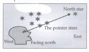
(i) In ancient times, people used to determine direction during the night with the help of stars.
(ii) The North Star indicates the North direction. It is also called the Pole Star.
(iii) It always remains in the same position in the sky.
(iv) We can locate the position of the Pole Star with the help of the Saptarishi.
(v) If we look at the figure given below, we will notice that if an imaginary line is drawn joining the pointer stars and it is extended further, it will point words the Pole Star.
9.
The state, Kerala derives its name from the Malayalam word 'Kera', meaning the coconut palm and 'Alam', meaning the place. Coconut forms a part of the daily diet of the people of Kerala.
Coir is an important ecofriendly material which is obtained from coconut husk. Kerala is considered to be the largest producer of coir. Products such as flooring, mats, carpets, wall hangings and bags are made from coir fibre.
10.
(i) In India, 82°30' E is taken as a standard meridian because for every 1° longitude time difference is 4 minutes. India's total longitudinal extent is 30°(97° E - 67° E = 300E). So, total time difference is 30 x 4 = 120 minutes or 2 hours, which means the time difference between Gujarat and Arunachal Pradesh would be 2 hrs. To avoid such confusion and to have same time all over the country, we have taken a standard meridian.
(ii) Indian Standard Time (IST) is 5:30 hours (5 hours 30 minutes) ahead of Greenwich Mean Time.
11.
(i) Some of the raw materials that the Harappans used were available locally and many items such as copper, tin, gold, silver and precious stones had to be brought from distant places.
(ii) The Harappans probably got copper from present-day Rajasthan and even from Oman in West Asia.
(iii) Tin, which was mixed with copper to produce bronze, may have been brought from present day Afghanistan and Iran.
(iv) Gold could have come all the way from present day Karnataka and precious stones from present day Gujarat, Iran and Afghanistan.
12.
(i) The Mesolithic period, also referred to as the Middle Stone Age, witnessed environmental changes like the melting of glaciers and their replacement by thick forests.
(ii) This period stretches from 12,000 years ago till about 10,000 years ago.
(iii) The people of this period used small tools called microliths, such as spearheads and arrow heads.
(iv) Probably, agriculture was also practiced to some extent.
(v) Domestication of animals, most importantly of dogs, started.
13.
Many people did not accept the system of Varna laid down by the Brahmins.
(i) Some kings thought they were superior to the priests.
(ii) Others felt that birth could not be a basis for deciding which varna people belonged to
(iii) Some people felt that there should be no differences amongst people based on occupation.
(iv) Others felt that everybody should be able to perform rituals.
(v) Some condemned the practice of untouchability.
(vi) Also, there were many areas in the subcontinent, such as the northeast, where social and economic differences were not very sharp, and where the influence of the priests was limited.
14.
(i) Kings adopted a number of steps to win the support of men who were powerful either economically or socially or because of their political and military strength.
(ii) Some important administrative posts were now hereditary.
(iii) Sometimes, one person held many offices. For instance, besides being a Maha-Danda-Nayaka, Harisena was a Kumar-Amartya, Meaning an important minister.
(iv)Besides, some important men had a say in local administration. These included chief bankers or merchants of the city, the leaders of the merchant caravans, the chief craftsmen, and the head of the tribes.
15.
(i) Administration: During Ashoka's time, the king was the head of the state and was assisted by 'rnantriparishad' -the council of ministers. His empire was divided into provinces and the provinces were divided into districts. Villages were the smallest units. City was the basic trade centre.
(ii) Pataliputra: The capital city was administrated by the Chief-Nagarika with the City Council of 30 members, who, in turn, had 6 boards, each board incharge of various functions. All the cities were administered like Pataliputra.
(iii) Education: It was fairly widespread and teaching was mainly the job of the Brahmins. Buddhist monasteries were the educational institutions. Famous educational centers were established in Taxila, Ujjain, and Varanasi.
(iv) Revenue: The income for the empire came through taxes which were both in cash and kind, levied on land holding and trade. Tax collection was hardly very strict.
(v) Army: The army was very huge and functioned under Senapati who directly reported to the king. The Soldiers were well equipped with swords, bows and arrows and spears and were looked after very well. Army was divided into six branches. They were: Cavalry, Infantry, Chariots, Elephants, Transport and Navy.
(vi) Economy: The administrators helped villagers by clearing forest area and starting new settlements. They also helped people start agriculture and animal husbandry.
16.
(i) Grains were used as seeds, food and as gifts.
(ii) The early man stored grains in large pots, woven baskets or in pits, which were dug in the ground.
(iii) When the early man started farming, he had to stay at one place for a long time looking after plants, watering, weeding and protecting them from animals and birds till the grain ripened. So, instead of wandering from place to place in search of food, he began to live a settled life.
17.
(i) Between 2200 and 1900 years ago, Arikamedu was a coastal settlement where ships unloaded goods from distant lands.
(ii) A massive brick structure, which may have been a warehouse was found at the site.
(iii) Other findings include pottery from the Mediterranean region, such as amphorae (tall double-handled jars that contained liquids such as wine or oil) and stamped red-glazed pottery, known as Arretine Ware which was named after a city in Italy.
(iv) Roman lamps, glassware and gems have also been found at the site.
(v) Small tanks have been found that were probably dyeing vats, used to dye cloth.
18.
Gangabai said that it is the Ward Councillor whom people should go to and protest, since the people elected him.
She gathered a small group of women and went to his house.
Gangabai described the situation in the locality to him The Councillor promised to go with them the next day to meet the Commissioner.
He asked Gangabai to get a petition signed by all of the adults in the locality saying that garbage was not being collected.
The Councillor suggested that taking the local sanitation engineer with them the next day might be a good idea.
19.
It is a busy street in a city with hawkers and vendors. Various types of vehicles like cycles, buses, cars are plying on the roads.
Some of the people are trying to board the bus.
Many other people are buying goods from various shops. Some children are going to school. Also some people are taking their meals at dhaba.
20.
Mountains can be divided into three groups. They are as follows:
Block mountains They are created when large areas are broken and displaced vertically. For example-the Vosges mountain.
Volcanic mountains They are formed by volcanic activities. They are formed by the deposition of lava. For example-Mt. Kilimanjaro.
Folded mountain Folded mountains are with rugged relief and high conical peaks. For example- Himalayan mountains and Alps. while others with rounded features and low elevation like-Ural mountains.
21.
A Village Panchayat is divided into wards. Each ward elects a representative who is known as the Ward Member, also called Panch. All the members of the Gram Sabha also elect a Sarpanch who is called Panchayat President. The ward Panchs and the Sarpanch form the Gram Panchayat. The tenure of the Gram Panchayat is five years.
The Gram Panchayat and Gram Sabha have a common secretary. He is a person whom the government appoints. Thus, he is not an elected person. The Secretary is responsible for calling the meeting of the Gram Sabha and Gram Panchayat. He also keeps a record of the proceedings of the meetings.
22.
(i) Asia It is the largest continent. It covers about one- third of the total land area of the earth. The tropic of cancer passes through this continent. Asia is separated from Europe by the Ural mountains on the West.
(ii) Africa It is the second largest continent after Asia. The Equator runs almost through the middle of the continent. A large part of Africa lies in the Northern hemisphere. The tropic of cancer and tropic of Capricorn pass through it. The continent is bound on all sides by oceans and seas.
(iii) North America North America is the third largest continent of the world. It is linked to South America by a very narrow strip of land called the Isthmus of Panama. The continent lies completely in the Northern and Western hemisphere.
(iv) South America South America lies mostly in the Southern hemisphere. The Andes runs through its length from North to South. South America has the world's largest river, the Amazon.
23.
(i)The Jaina monastery in the picture is situated In Odisha.
(ii)Jaina monks lived and meditated In these rooms.
24.
A map is a representation or drawing of the earth's surface or a part of its area drawn on a flat surface according to a scale. There are different types of maps.
Some of them are as follows:
(i) Physical maps Maps showing natural features of the earth such as mountains, plateaus, plains, rivers, oceans etc are called physical or relief maps.
(ii) Political maps Maps showing cities, towns, villages and different countries and states of the world with their boundaries are called political maps.
(iii) Thematic maps Maps with specific information like road maps, rainfall maps, maps showing distribution of forests, industries etc are known as thematic maps.
25.
Broadly. the major seasons recognised in India are:
Cold Weather Season (Winter) December to February: During the winter season. cool. dry winds blow from North to South.
Hot Weather Season (Summer) March to May: In the hot weather season, sun rays more or less directly fall in this region.
South-West Monsoon Season (Rainy) June to September: This season is marked by the onset and advance of monsoon. The winds blow from Arabian Sea and Bay of Bengal towards the land.
Season of Retreating Monsoon (Autumn) October and November: Winds move back from the mainland to the Bay of Bengal. This is the season of the retreating monsoons.
26.
The silent sentinels behind the story of the megaliths were as follow:
(i) The big stones or the stone boulders are known as megaliths which were carefully arranged by people, and were used to mark burial sites.
(ii)The practice of erecting'megaliths began about 3000 years ago, and was prevalent throughout the Deccan, South India, in the North-East and Kashmir.
(iii) Some of the megaliths can be seen on the surface, other megalithic burials are often underground.
(iv) Archaeologists often find that a circle of stone boulders or a single large stone standing on the ground, are the only indications of burials.
(v) The burials have some common features as the dead were buried with distinctive pots, which are' called Black and Red Ware. Tools and weapons of iron and sometimes, skeletons of horses, horse equipment and ornaments of stone and gold are also found.
27.
Each pilgrim left experiences of their journies
• They wrote about the dangers they faced and experiences during their travels to the
countries and the monasteries.
• They wrote about the books they carried back with them
• Xuan Zang went back China through the land route. He carried statues of Buddha made of
gold, silver and sandalwood
• He also took about 600 manuscripts loaded on about 20 horses He spent his life converting the manuscripts from Sanskrit to Chinese.
• Fa Xian also took many manuscripts with him He also gave us detailed description of his journey and contemporary Indian society.
28.
(i)Karle, present-day Maharashtra
(ii)Monks and nuns lived and meditated in these caves or shelters.
29.
(i) This manuscript was written about a thousand years ago.
(ii) The palm leaves were cut into pages and tied together to make books.
(iii) A palm leaf manuscript.
30.
31.
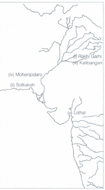
32.
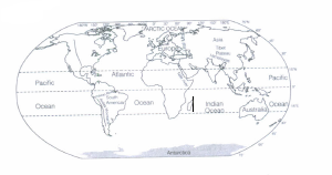
(A) Europe
(B) Asia
(C) Antarctica
(D) Sourh America
(E) Australia
(F) Indian ocean
(G) Pacific ocean
(H) Atlantic ocean
(I) Ural mountains
33.
Yes, we can list three ways in which the different geographical location of these regions (Kerala and Ladakh) would be influence:
| Kerala | ladakh | |
|---|---|---|
| Food | Rice, fish, vegetables | Meat and milk. |
| Clothes | Cotton and synthetic cloths. Loose cotton. No woollen clothes | Woolen and fur clothes. |
| Work | Fishing, agriculture | Sheep rearing, wool collection, trading |
34.
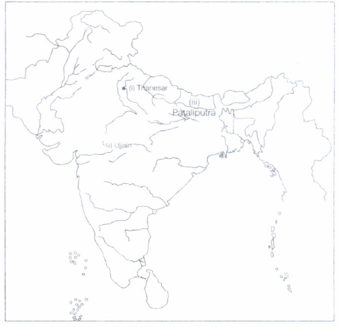
35.
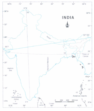
36.
Hints for students
(i) Name and location of your state or Union Territory, write the name of your region.
(ii) Look carefully in the map, is any janapada site in your state/UTs.
(iii) If yes, name that janapadas.
(iv] If not, look all directions of your state (East, West, North, South).
(v) See the map
37.
38.
39.
The main problems faced by the vendors are:
(i) Shops are usually temporary in structures.
(ii) Dismantling of their shops any time by the police.
(iii) They have no security.
(iv) There are certain parts of the city where these vendors are not allowed to enter
40.
The drawbacks of cutting trees are as follows:
(i) Due to cutting of trees, several species of wildlife are declining rapidly.
(ii) It is also leading to increasing natural disasters such as floods.
(iii) It will lead to increase in global warming.
41.
Poverty and illiteracy are the two main factors responsible for the sufferings of farmers in rural India. A large proportion of poor people live in rural areas. Poverty remains a chronic condition for 30% of India's rural population.
42.
Dalits are not permitted to drink water from public wells, attend temple prayers, wear shoes in front of an upper caste or drink from the same cups in tea stalls. They have to face various sorts of discrimination and atrocities from the upper castes.
43.
India is well-connected with South West Asia, Africa and Europe and North and South America through the Suez Canal and Cape of Good Hope. Suez Canal is an international highway of trade and commerce and India gets advantages of this highway, linking East with West.
44.
The portion of the Earth facing the Sun would always experience day, thus bringing continuous warmth to the region. The other half would remain in darkness and would be freezing cold all the time. Life would not have been possible in such extreme conditions.
45.
(i) Women and men from different cultural, religious and regional backgrounds were united together to fight against the British rule. They worked together to plan joint actions to be taken against the Britishers. They went to jail together and found different ways to oppose the British.
(ii) India does not have a uniform culture. It has diversity of cultural practices, languages, customs and traditions. The people of India get an opportunity to enjoy all these diversities in the nature in their day-to-day life.
46.
The temperature of a planet depends on the distance from the Sun. Mercury is very close to the Sun and hence, it is the very hottest planet in the solar system. Its temperature goes above 400oC.
47.
Maps which focus on specific information, such as road maps, rainfall maps, showing distribution of forests, industries, etc. are known as Thematic Maps. Suitable titles may be given on the basis of information provided by these maps.
48.
Importance of latitudes:
(i) They help us to locate the position of a place away from the Equator.
(ii) They help us to know the temperature of a place.
49.
(i) Generally, houses were either one or two storey high with rooms built around a courtyard.
(ii) Most houses had a separate bathing area and some had wells to supply water.
50.
Some kings tried to control large portions of the Silks Route because they could benefit from taxes, tributes and gifts that were brought by traders travelling along the route. In return, they protected the traders who passed through their kingdoms from attacks by robbers.
51.
It is important to study about our past as it gives a lot of information regarding the political, social, economic and cultural life of the people in the earlier days. By studying about our past:
(i) We can find out about the eating habits, the clothing and housing pattern of the people of the earlier times.
(ii) We can gather information about the lives of hunters, farmers, merchants, priest, craftsmen, musicians, poets and scientists.
(iii) We can learn about the lives of children, the songs they sang, the plays they saw, the games that they played and the kind of toys with which they played.
52.
The people who composed the hymns described themselves as Aryas and called their opponents Dasas or Dasyus. These were the people who did not perform sacrifices and probably spoke different languages.
53.
Sangha was an association of those who left their homes. As both Mahavira and Buddha felt that only those who left their homes could gain true knowledge, they arranged for them to stay together in the Sangha.
54.
Complicated decisions usually affect the entire city and therefore these decisions are taken by groups of Councillors who form committees to decide and debate issues.
55.
| Public service | What did you notice about their work? | Area covered | What do they need to do in order to the facility? | Problems faced by those managing the service | Problems faced by people | Improvements that can be made |
|---|---|---|---|---|---|---|
| Fair price shop (ratio shop) | The shop was open. Three people came. They all had yellow cards. They bought sugar and rice. Kerosene was not available. | This shop covers two villages. | They need ration card. This has to be made at the tehsil office. | There is not enough supply of kerosene. | Rice is of very bad quality. We never get kerosene. | Improve quality of rice. Make kerosene available. The fair price shop should be kept open everyday. |
| Health centre | The centre was open. Several people were in queue. Some had the papers in their hands. Some of them were new. | This centre covers the entire locality. | You have medical card. New medicines may also be got for new patients | Some medicines were in short supply. Doctors and para-medical staff were in sufficient numbers. | A number of medicines are necessary. | The quality of medicines should be improved and need to be insufficient supply. |
| Milk society | The office was open. Milk vendors were there. They had milk pots. |
Book is required for entry. One has to become a member of the society | Collection was smooth. No problem was faced. | Milk rates need revision. | Need to improve the refrigeration facilities. |
56.
The use of natural/resources in wasteful manner and pollution done by us are the major causes for the destruction of natural resources. The overuse or exploitation of such resources also cause destruction.
57.
Yes, there was a problem with the BPL list that the Gram Sabha was finalising. The problem was, Natwar and Birju were listed in the BPL list while both were not eligible for the BPL. The name of Om Prakash was not listed even though he was very poor and eligible for the list.
58.
The four major domains of the earth are lithosphere, atmosphere, hydrosphere and biosphere.
59.
Five ways in which the non-whites were discriminated against are:
(i) Non-whites were not allowed to vote.
(ii) The best land was reserved for the white people and non-whites had to live on the worst available land.
(iii) Hospitals and ambulances were separate for whites and non-whites.
(iv) There were separate trains and buses.
(v) The bus stops were different for them.
60.
In Athens, it was not a true democracy, as the right of women was ignored, slaves were ill-treated and not given citizenship.
61.
Paper is used for:
(i) Making notebooks on which we write.
(ii) Making books.
(iii) Making newspapers.
(iv) Packing materials.
(v) Postcard, envelopes, postal stamps, revenue stamps.
(vi) Artificial flowers for decorative purpose.
(vii) Making games items like kite.
62.
The government needs to make rules for everyone in the form of laws because of the following reasons:
(I) To provide equality and justice to all.
(ii) To maintain peace.
(iii) To administer country efficiently.
63.
Lord Buddha taught in Prakrit language and King Ashoka issued his inscriptions in Prakrit language.
64.
Blacksmiths, potters, carpenters and weavers would have been present in both villages and cities.
65.
Ashoka's attitude towards the neighbouring people was totally different from the contemporary Chinese emperors. For example the Chinese emperors constructed wall to protect the northern frontier of the empire from the pastoral people, whereas Ashoka expanded its empire of dhamma by sending officials to spread the message of non-violence. This example presents the open mindedness of Ashoka.
66.
On excavation archaeologists have found bones of wild animals in the lower most levels. On upper levels, they found cattle bones. This means that hunting wild animals was present much before herding was started.
67.
The tools such as knife or any sharp blade made of any hard metal, we use to cut the fruits now-a-days. Such knifes or sharp blades are usually made of iron and steel.
68.
(b)
Democracy and monarchy
69.
(a)
Paddy
70.
(a)
Australia
71.
(a)
Racial segregation on the basis of race and colour
72.
(a)
Political map
73.
(a)
Citadel
74.
(c)
China
75.
(a)
Pottery
76.
(d)
Rice
77.
(c)
Both (a) and (b)
78.
(b)
An astronomer
79.
(a)
cover them.
80.
(a)
In an export garment unit
81.
(d)
Both 'a' and 'c'
82.
(c)
Sailing
83.
(b)
Anwar
84.
(c)
Kerala
85.
(b)
Charioteer
86.
(a)
Affected
87.
(c)
Shrigupta
88.
89.
(b)
Revolution
90.
(b)
Dr. BR Ambedkar
91.
(a)
the poles
92.
(a)
300,000 km/sec
93.
(b)
Rashtrapati
94.
(b)
Sheep and goat
95.
(b)
Kshatriya
96.
(c)
Kurnool

6th Standard CBSE Syllabus & Materials
6th Standard CBSE
CBSE 6th Social Science Locating Places on the Earth - New Sample Question Papers Study Material - QB365 Set A
NEW6th Standard CBSE
CBSE 6th Science A Journey Through States of Water - New Sample Question Papers Study Material - QB365 Set A
NEW6th Standard CBSE
CBSE 6th Science Temperature and its Measurement - New Sample Question Papers Study Material - QB365 Set A
NEW6th Standard CBSE
CBSE 6th Science Materials Around Us - New Sample Question Papers Study Material - QB365 Set A



CBSE 6th Standard CBSE Subjects
CBSE Standards