100% FREE ACCESS
7th Standard CBSE Syllabus & Materials
7th Standard CBSE
CBSE 7th Social Science Theme E - Understanding Market - New Sample Question Papers Study Material - QB365 Set A
NEW7th Standard CBSE
CBSE 7th Social Science Theme E - From Barter to Money - New Sample Question Papers Study Material - QB365 Set A
NEW7th Standard CBSE
CBSE 7th Social Science Theme D - The Constitution of India- An Introduction - New Sample Question Papers Study Material - QB365 Set A
NEW7th Standard CBSE
CBSE 7th Social Science Theme D - From the Rulers to the Ruled : Types of Governments - New Sample Question Papers Study Material - QB365 Set A
NEW7th Standard CBSE
CBSE 7th Social Science Theme B - The Age of Reorganisation - New Sample Question Papers Study Material - QB365 Set A
NEW7th Standard CBSE
CBSE 7th Social Science Theme B - The Rise of Empires - New Sample Question Papers Study Material - QB365 Set A

Published on: 31/10/2019
Download CBSE Class 7th Standard CBSE Social Science question papers, sample papers, important questions, and previous year solved papers in PDF format. Get free study materials, NCERT solutions, and exam preparation resources for Class 7th Standard CBSE Social Science
Questions + Answers key
Take MCQ Social Science Test
1.
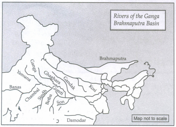
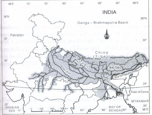
On an outline map of the Indian sub-continent, draw the rivers Ganga and Brahmaputra from the source to the mouth. Also show the important tributaries of both rivers.
2.
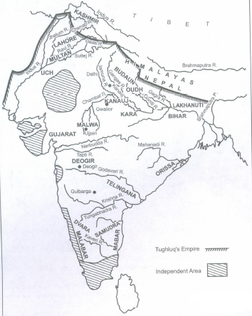
On an outline map of India, identify the provinces of Delhi Sultanate during Muhammad Tughlaq's reign and write their names near their locations
3.
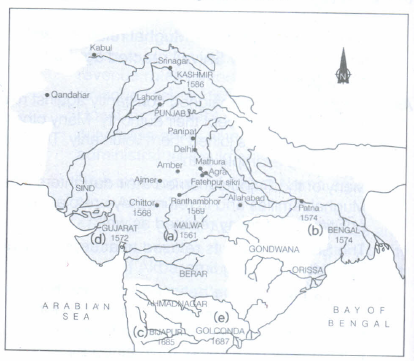
On the map of India, mark the following areas of military campaigns under Akbar and Aurangzeb.
(a) Malwa (1561)
(b) Bengal (1574)
(c) Bijapur (1685)
(d) Gujarat (1572)
(e) Golconda (1687)
4.
On an outline map of the Indian subcontinent, draw the rivers Ganga and Brahmaputra from the source to the mouth. Also, show the important tributaries of both the rivers.
5.
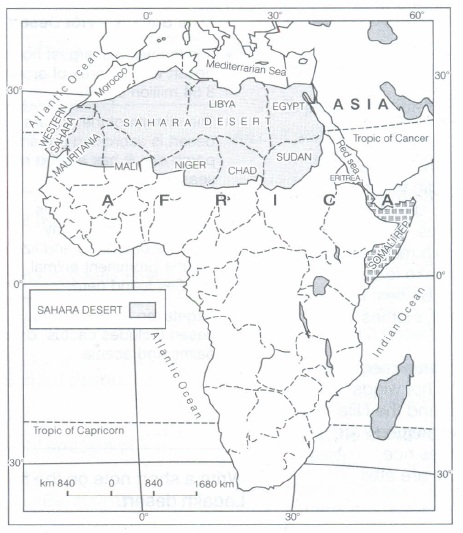
On the outline map of Africa, mark the Sahara desert and any four countries around it.
6.
Plot the location of the tribes mentioned in this chapter on a map. For any two, discuss whether their mode of livelihood was suited to the geography and the environment of the area where they lived.
7.
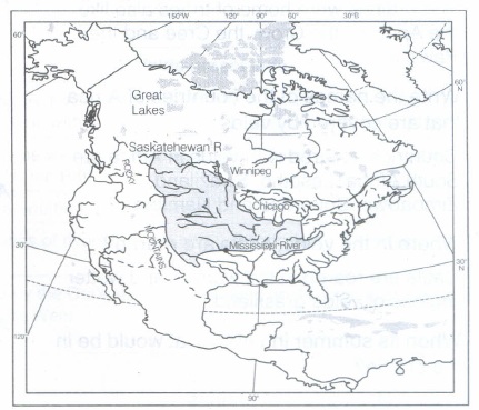
On an outline map of North America, mark the Rocky Mountains, the Great Lakes, river Mississippi, river Saskatchewan, the cities - Chicago and Winnipeg.
8.
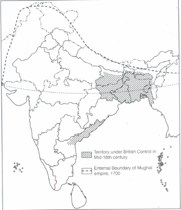
(i) In the map of India, mark the territory under British Control during the mid-18th Century.
(ii) Also mark external boundary of Mughal empire, 1700
9.
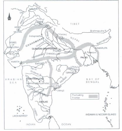
Look at Map and find out whether there were any kingdoms in the state in which you live.
10.
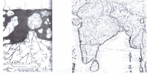
Compare either Map 1 or Map 2 with the present day map of the subcontinent listing as many similarities and differences (page no) as you can find.
1.
2.
3.
4.
5.
The answer map isgiven below
6.
Several tribes live in different parts of India. See the map given below
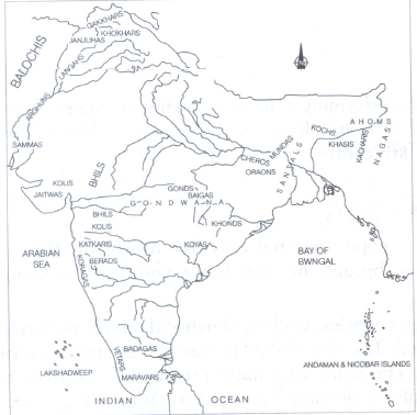
These tribes settled temporarily at the places which suited them as per their need and livelihood. Whenever, they found the environment or their mode of living unfavourable, they migrated to other suitable places.
(i) The Khokhar tribes are from the Punjab region of Pakistan and North Western India. They were designated as an agricultural tribal and were usually classified as Jat and Rajput. There were several subdivisions of the Khohhan bribe, e.g., Bandial, Bhachan, Dhaulka, Ganjial, Jalap etc. All of them were mainly dependent on their fertle land for livelihood.
(ii) The Gaddia are people who normally reside in the Mandi, Kangra and Bilaspur district of Himachal Pradesh. Their main occupation is Shepherding. They make their livelihood by rearing and selling sheep, goats, mules and horses. They spent their winter in the low hills of Siwalik range, grazing their flocks in forests. By April, they moved on to higher mountain meadows when the snow melted. By September, they again began their return movement.
7.
The map is given below
8.
9.
Yes, there were Kingdoms in the following states
| STATES | KINGDOMS |
| West Bengal | Palas |
| Orissa | Utkalas, Gangas, Kalinga |
| Tamil Nadu | Cholas and Pandyas |
| Madhya Pradesh | Gurjara - Pratharas, Chandellas, Paramaras |
| Kerala | Cheras |
| Maharastra | Rashtrakutas |
| Karnataka | Rashtrakutas |
| Gujarat | Anartka |
| Rajasthan | Chahamanas |
10.
Differences Map 1 and Map 2 given in the NCERT text book (Map 2) represent two different times
Map 1 was made in 1154 CE by Al-ldrisi, an Arab geographer, the map given here is the map of Indian subcontinent from his larger map of the world.
Map 2 was made by a French cartographer in 1720. Both maps are quite different from each other in mode of presentation and contexts. However, both traced the outlines of the area of Indian subcontinent in their cartography.
Similarities Map 1, South India was at that place where North India is at present and Sri Lanka is the island the top. Name of place were in Arabic. Today's map of India is far ahead of Map 1 and Map 2. It is made to scale and shows clear-cut boundaries and areas.

7th Standard CBSE Syllabus & Materials
7th Standard CBSE
CBSE 7th Social Science Theme B - New Beginnings : Cities and States - New Sample Question Papers Study Material - QB365 Set A
NEW7th Standard CBSE
CBSE 7th Social Science Theme A - Climates of India - New Sample Question Papers Study Material - QB365 Set A
NEW7th Standard CBSE
CBSE 7th Social Science Theme A - Geographical Diversity of India - New Sample Question Papers Study Material - QB365 Set A
NEW7th Standard CBSE
CBSE 7th Science Earth, Moon and the Sun - New Sample Question Papers Study Material - QB365 Set A



CBSE 7th Standard CBSE Subjects
CBSE Standards