100% FREE ACCESS
9th Standard Syllabus & Materials
9th Standard
TN 9th Tamil உள்ளத்தின் சீர் -கற்கண்டு (இலக்கணம்) - தொடர் இலக்கணம், ஆகுபெயர் Important Questions And Answers Study Material - QB365 Set A
NEW9th Standard
TN 9th Tamil உள்ளத்தின் சீர் -விரிவானம் (துணைப்பாடம்) - தாய்மைக்கு வறட்சி இல்லை! Important Questions And Answers Study Material - QB365 Set A
NEW9th Standard
TN 9th Tamil உள்ளத்தின் சீர் -கவிதை பேழை (செய்யுள்) - மார்கழி பெருவிழா Important Questions And Answers Study Material - QB365 Set A
NEW9th Standard
TN 9th Tamil உயிருக்கு வேர்-இலக்கணம் - பகுபத உறுப்பிலக்கணம் Important Questions And Answers Study Material - QB365 Set A
NEW9th Standard
TN 9th Tamil அமுதென்று பேர் - இலக்கணம்-எழுத்து -அளபெடை Important Questions And Answers Study Material - QB365 Set A
NEW9th Standard
TN 9th Tamil அமுதென்று பேர்-துணைப்பாடம் - ஆறாம்திணை Important Questions And Answers Study Material - QB365 Set A

Published on: 07/12/2019
Maping Skills
Download Tamil Nadu 9th Standard Social Science question papers, model tests, one-mark questions, important questions, and public exam papers in PDF format. Free study materials and answer keys for TN State Board students.
Questions + Answers key
Take MCQ Social Science Test
1.
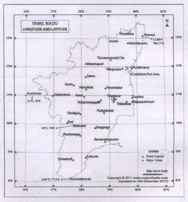
With the help of an atlas, mark the following on the outline map of Tamil Nadu.
a) The latitude and longitude of Chennai.
b) Mark the city located at 100N, 780E.
c) Locate the city approximately on 110N and 760E.
d) Find the latitude and longitude of Kanyakumari and mark it.
2.
GPS technology has tremendous applications in _________
Mobile phones
Watches
ATMs
All these
3.
Aerial photographs were taken by Felix Nadar in __________
1858
1852
1858
1860
4.
A synoptic chart means ________
Weather map
Travelogue
Thematic map
General maps
5.
International boundaries are marked in ______ colour codes.
Brown
Blue
Red
Pink
6.
The foundation for map making in India was laid during the period _____________
Aryan
Vedic
Gupta
Chola
7.
Write about the hardware and software functions of a GIS.
8.
Mention the advantages of GIS.
9.
Remote sensing can be either passive or active - Explain
10.
Mention the three types of map symbols.
11.
Who is a cartographer?
12.
Explain the Global Navigation Satellite System (GNSS).
13.
What are the advantages and disadvantages of Remote Sensing?
14.
Explain the types of map.
1.
2.
(d)
All these
3.
(c)
1858
4.
(a)
Weather map
5.
(d)
Pink
6.
(b)
Vedic
7.
The hardware and software functions of a GIS are
(i) Data input and verification
(ii) Compilation
(iii) Storage
(iv) Updating and changing
(v) Management and exchange
(vi) Manipulation
(vii) Retrieval and presentation
(viii) Analysis and combination
8.
The advantages of GIS are
(i) Maps produced by GIS analysis can be used to pinpoint problem areas.
(ii) GIS finds its strongest use in resources management, telecommunications and urban and regional planning.
(iii) GIS helps in planning the land-use requirements. The local government uses GIS for taxation and planning.
9.
(i) Remote sensing can be either passive or active.
(ii) Active systems emit their own source of light energy such as RADAR:
(iii) Passive systems depend on sunlight as energy source
10.
(i) Point Symbols - Buildings, dipping tanks, trigonometrical beacons
(ii) Line Symbols - Railways, roads, power lines, telephone lines
(iii) Area Symbols - Cultivated lands, ponds, orchards and vineyards
11.
A cartographer is one who measures, analyzes and interprets geographical information to create maps and charts for political, cultural and educational purposes.
12.
(i) In the 21st century, GNSS has become a part of our lives to promote the safety and convenience of transport.
(ii) Global Navigation Satellite System (GNSS) is a satellite system connected with a small electronic receiver or tracker to locate, monitor and track a user's vehicle wherever in the world.
(iii) It can also set up instant alerts when a driver of a vehicle speeds or deviates from a particular area.
(iv) GNSS applications are used in tracking or mapping vehicles, ships and aircraft.
(v) A group of satellites (Space Segment) working with a network of ground stations (Control Segment) provide location data.
(vi) The receiver (User Segment) converts satellite signals into location, speed and time data.
(vii) Examples of GNSS:
(a) Europe's Galileo
(b) USA's NAVSTAR Global Positioning System (GPS)
(c) Russia's Global'naya Navigatsionnaya Sputnikovaya Sistema (GLONASS)
(d) China's BeiDou Navigation Satellite System
(e) India's NAVIC satellite system
13.
(a) Advantages of Remote sensing:
(i) It is the only practical way to obtain data from inaccessible regions, e.g. Antarctica, Amazon forest.
(ii) It helps in constructing cheap base maps in the absence of detailed land surveys.
(iii) It detects the spread of natural calamities such as flood, forest fire and volcanic eruption, so that immediate rescue operations and planning can be carried out.
(b) Disadvantages of Remote sensing:
(i) It is difficult to prepare large scale maps from obtained satellite data.
(ii) The technique is very expensive for small areas requiring one time analysis.
14.
(a) On the basis of scale, maps can be classified into:
(i) Large scale maps: Large amount of detail; can only show a small area.
(ii) Small scale map: Small amount of detail; can show a large area.
b) On the basis of utility and purpose, they are classified as:
(i) General maps / Topographic Maps (physical and political maps)
(ii) Thematic map (spatial variations of single phenomena)
(iii) Special purpose maps (Braille maps for blind people, maps for neo-literates, military maps, navigational charts, etc).

9th Standard Syllabus & Materials
9th Standard
TN 9th Tamil உள்ளத்தின் சீர் - திருக்குறள் Important Questions And Answers Study Material - QB365 Set A
NEW9th Standard
TN 9th Tamil உள்ளத்தின் சீர் - மணிமேகலை Important Questions And Answers Study Material - QB365 Set A
NEW9th Standard
TN 9th Tamil உள்ளத்தின் சீர் - ஏறு தழுவுதல் Important Questions And Answers Study Material - QB365 Set A
NEW9th Standard
TN 9th Tamil உயிருக்கு வேர் - தண்ணீர் Important Questions And Answers Study Material - QB365 Set A



Tamilnadu Stateboard 9th Standard Subjects
Tamilnadu Stateboard Standards