100% FREE ACCESS
9th Standard Syllabus & Materials
9th Standard
TN 9th Tamil உள்ளத்தின் சீர் -கற்கண்டு (இலக்கணம்) - தொடர் இலக்கணம், ஆகுபெயர் Important Questions And Answers Study Material - QB365 Set A
NEW9th Standard
TN 9th Tamil உள்ளத்தின் சீர் -விரிவானம் (துணைப்பாடம்) - தாய்மைக்கு வறட்சி இல்லை! Important Questions And Answers Study Material - QB365 Set A
NEW9th Standard
TN 9th Tamil உள்ளத்தின் சீர் -கவிதை பேழை (செய்யுள்) - மார்கழி பெருவிழா Important Questions And Answers Study Material - QB365 Set A
NEW9th Standard
TN 9th Tamil உயிருக்கு வேர்-இலக்கணம் - பகுபத உறுப்பிலக்கணம் Important Questions And Answers Study Material - QB365 Set A
NEW9th Standard
TN 9th Tamil அமுதென்று பேர் - இலக்கணம்-எழுத்து -அளபெடை Important Questions And Answers Study Material - QB365 Set A
NEW9th Standard
TN 9th Tamil அமுதென்று பேர்-துணைப்பாடம் - ஆறாம்திணை Important Questions And Answers Study Material - QB365 Set A

Published on: 15/10/2019
Maping Skills
Download Tamil Nadu 9th Standard Social Science question papers, model tests, one-mark questions, important questions, and public exam papers in PDF format. Free study materials and answer keys for TN State Board students.
Questions + Answers key
Take MCQ Social Science Test
1.
What are the components of remote sensing?
2.
Define remote sensing.
3.
What are the components of a map?
4.
What is a map?
5.
Name the different methods to represent the Earth.
6.
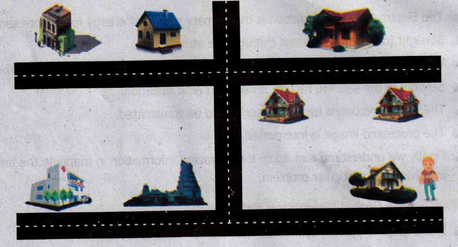
Imagine you are a cartographer. Draw the map of your area.
7.
Can you imagine a world without satellites?
8.
Explain the major uses of GPS? Explain about any one.
9.
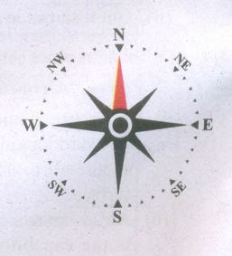
Write a note on directions with relevant diagram.
10.
What do you mean by the term 'scale of the map'? Explain its classification.
1.
Components of remote sensing are
(i) Energy source
(ii) Transmission path
(iii) Target
(iv) Sensor
2.
(i) Remote Sensing refers to the observation and measurement of earthly objects without touching them.
(ii) 'Remote' means far away and 'Sensing' means observing or collecting information.
(iii) Remote sensing means acquiring information of things/places from a distance, using a variety of tools and methods.
3.
A map should include the following components namely, the title, scale, direction, grid reference, projection, legend, conventional signs and symbols
4.
(i) A map is the basic tool of a geographer.
(ii) It illustrates the earth's surface clearly and effectively through a combination of drawings, words and symbols.
(iii) Thus, maps form an integral part of teaching geography.
(iv) A map is a location guide.
5.
(i) A map is the basic tool of a geographer. It illustrates the earth's surface clearly and effectively through a combination of drawings, words and symbols.
(ii) A map projection is a way of showing the spherical shaped earth on a flat piece of paper.
(iii) A map projection is a systematic transformation of the latitudes and longitudes of location from the surface of a sphere or an ellipsoid into locations on a plane.
(iv) A Globe is a spherical model of earth. Globe serves similar purposes to maps but unlike maps do not disturb the surface that they portray except to scale it down. A globe of earth is called terrestrial globe.
6.
7.
It is difficult to imagine a World without satellites, because of the following reasons:
(i) Navigation and communication is possible only because of satellites.
(ii) GPS is an important benefit of satellites.
(iii) In Science, we do very many things with the help of satellites.
8.
(i) GPS technology has tremendous applications in everything from mobile phones, watches, bulldozers, shipping containers and ATMs.
(ii) The main purpose of GPS is to help in providing accurate transport data (distance, route and direction).
(iii) It helps in military searches and rescue in wars.
(iv) It can work as a reliable tourist guide.
(v) GPS helps during accident and rescue efforts speeding the delivery of emergency services and disaster relief.
(vi) Weather forecasting, earthquake monitoring and environmental protection can be done effectively by using GPS.
9.
(i) Maps are drawn normally with north orientation.
(ii) North direction in a map is always towards the North Pole of the earth.
(iii) If you position yourself looking at the North Pole, on your right will be the east; your left will be the west; at your back, will be south.
(iv) These four main directions are called the cardinal directions.
(v) Direction is usually indicated on a map by a North-South line, with the North direction represented by an arrow head.
(vi) The memory technique to recall cardinal direction is the sentence.
| Never | Eat | Soggy | Wheaties |
| North | East | South | West |
10.
(i) Scale is one of the components of map.
(ii) Scale makes it possible to reduce the size of the whole earth to show it on a piece of paper.
(iii) A scale is a ratio between the actual distance on the map to the actual distance on the ground.
(iv) Scales can be represented in three methods.
(v) They are the
(a) Statement,
(b) Representative Fraction (R.F) and
(c) Linear or Graphical scale methods.
(a) Statement Scale:
The statement scale describes the relationship of map distance to ground distance in words, such as one centimetre to ten kilometres. It is expressed as 1 cm = 10 km.
What do you mean by the term
(i) It describes the proportion or ratio of the map distance to ground distance. It is usually abbreviated as R.F. It is stated as 1/100000 or 1:100000
(ii) This means that one unit on the map represents 100,000 of the same unit on the ground.
(iii) This unit may be an inch or a centimetre or any other linear measurement unit.
(b) Representative Fraction (R.F.) = \(\frac{Distance \ on \ the \ map}{Distance \ on \ the \ Ground}\)
(c) Linear (or) Graphical scale: In geography, a linear scale is represented by a straight line divided into equal parts (Primary and secondary) to show what these markings represent on the actual ground. This scale helps in the direct measurement of distance on the map.

9th Standard Syllabus & Materials
9th Standard
TN 9th Tamil உள்ளத்தின் சீர் - திருக்குறள் Important Questions And Answers Study Material - QB365 Set A
NEW9th Standard
TN 9th Tamil உள்ளத்தின் சீர் - மணிமேகலை Important Questions And Answers Study Material - QB365 Set A
NEW9th Standard
TN 9th Tamil உள்ளத்தின் சீர் - ஏறு தழுவுதல் Important Questions And Answers Study Material - QB365 Set A
NEW9th Standard
TN 9th Tamil உயிருக்கு வேர் - தண்ணீர் Important Questions And Answers Study Material - QB365 Set A



Tamilnadu Stateboard 9th Standard Subjects
Tamilnadu Stateboard Standards