100% FREE ACCESS
9th Standard Syllabus & Materials
9th Standard
TN 9th Tamil உள்ளத்தின் சீர் -கற்கண்டு (இலக்கணம்) - தொடர் இலக்கணம், ஆகுபெயர் Important Questions And Answers Study Material - QB365 Set A
NEW9th Standard
TN 9th Tamil உள்ளத்தின் சீர் -விரிவானம் (துணைப்பாடம்) - தாய்மைக்கு வறட்சி இல்லை! Important Questions And Answers Study Material - QB365 Set A
NEW9th Standard
TN 9th Tamil உள்ளத்தின் சீர் -கவிதை பேழை (செய்யுள்) - மார்கழி பெருவிழா Important Questions And Answers Study Material - QB365 Set A
NEW9th Standard
TN 9th Tamil உயிருக்கு வேர்-இலக்கணம் - பகுபத உறுப்பிலக்கணம் Important Questions And Answers Study Material - QB365 Set A
NEW9th Standard
TN 9th Tamil அமுதென்று பேர் - இலக்கணம்-எழுத்து -அளபெடை Important Questions And Answers Study Material - QB365 Set A
NEW9th Standard
TN 9th Tamil அமுதென்று பேர்-துணைப்பாடம் - ஆறாம்திணை Important Questions And Answers Study Material - QB365 Set A

Published on: 25/10/2019
GEO - Maping Skills
Download Tamil Nadu 9th Standard Social Science question papers, model tests, one-mark questions, important questions, and public exam papers in PDF format. Free study materials and answer keys for TN State Board students.
Questions + Answers key
Take MCQ Social Science Test
1.
GPS consists of a constellation of ___________ satellites.
7
24
32
64
2.
Which one of the following maps show us a very large area with less details?
Large scale
Thematic
Physical
Small scale
3.
Standard symbols that are used in maps to convey a definite meaning are called ___________.
conventional signs and symbols
coordinates
grid references
directions
4.
________ indicates the purpose or theme of the map.
Title
Scale
Direction
Legend
5.
The new phase in topographical surveying in the 20th century is ___________.
toposheets
aerial photography
maps
satellite imagery
6.
Felix Nadar
7.
Egypt
8.
Travelogue
9.
NAVSTAR
10.
Thematic mapping
11.
What are geo objects?
12.
Mention the disadvantages of Remote sensing.
13.
What is a travelogue?
14.
Who is a cartographer?
15.
Define remote sensing.
16.
Mention a few surveying instruments.
17.
What is a map?
18.
Name the different methods to represent the Earth.
19.
Surveys help to prepare physical maps
20.
Conventional signs and symbols are standard symbols used on a map.
21.
Web cartography is one of the modern mapping techniques.
22.
Grid references are essential to find the exact location of places on a map.
23.
Satellite imageries stimulate map making.
24.
GIS and GPS
25.
Globe and Map
26.
Explain the types of map.
27.
Explain the major uses of GPS? Explain about any one.
28.
What do you mean by the term 'scale of the map'? Explain its classification.
29.
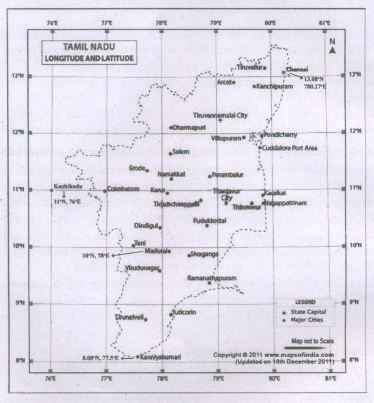
With the help of an atlas, mark the following on the outline map of Tamil Nadu.
a) The latitude and longitude of Chennai.
b) Mark the city located at 100N, 780E.
c) Locate the city approximately on 110N and 760E.
d) Find the latitude and longitude of Kanyakumari and mark it.
1.
(b)
24
2.
(d)
Small scale
3.
(a)
conventional signs and symbols
4.
(a)
Title
5.
(d)
satellite imagery
6.
Journalist
7.
Rope - stretchers
8.
Tourist map
9.
USA
10.
Political map
11.
(i) Geographical objects in the real world are matched to program objects known as geo objects.
(ii) Geo objects include placemarks, circles, polylines, rectangles, polygons and their collections.
(iii) Place markers indicate a place on a map.
12.
(i) It is difficult to prepare large scale maps from obtained satellite data.
(ii) The technique is very expensive for small areas requiring one time analysis.
13.
A travelogue includes all the information required by a tourist like communication, transportation, hotels, tourist spots, health centres, ATM, petrol stations etc.
14.
A cartographer is one who measures, analyzes and interprets geographical information to create maps and charts for political, cultural and educational purposes.
15.
(i) Remote Sensing refers to the observation and measurement of earthly objects without touching them.
(ii) 'Remote' means far away and 'Sensing' means observing or collecting information.
(iii) Remote sensing means acquiring information of things/places from a distance, using a variety of tools and methods.
16.
Geographers mainly use Chain, Prismatic compass, Plane table, Dumpy level, Abney level, Clinometre, Theodolite, Total Station and GNSS to measure the distance, angle, altitude and position of the area of survey.
17.
(i) A map is the basic tool of a geographer.
(ii) It illustrates the earth's surface clearly and effectively through a combination of drawings, words and symbols.
(iii) Thus, maps form an integral part of teaching geography.
(iv) A map is a location guide.
18.
(i) A map is the basic tool of a geographer. It illustrates the earth's surface clearly and effectively through a combination of drawings, words and symbols.
(ii) A map projection is a way of showing the spherical shaped earth on a flat piece of paper.
(iii) A map projection is a systematic transformation of the latitudes and longitudes of location from the surface of a sphere or an ellipsoid into locations on a plane.
(iv) A Globe is a spherical model of earth. Globe serves similar purposes to maps but unlike maps do not disturb the surface that they portray except to scale it down. A globe of earth is called terrestrial globe.
19.
(i) Surveying is done to measure the angle, direction, area, height and distance of an object or place on the surface of the earth using instruments.
(ii) Surveying techniques are used to obtain the field data and to prepare maps.
(iii) Hence knowledge of surveying helps to prepare physical maps.
20.
(i) A map is a global language and it needs to be drawn according to the international standards.
(ii) Conventional signs and symbols are standard symbols used on a map and explained in the legend to convey a definite meaning.
21.
(i) Web mapping is the process of using the maps delivered by geographic information systems.
(ii) The advent of web mapping can be regarded as major new trend in cartography.
(iii) Until recently cartography was restricted to a few companies, institutes, mapping agencies.
(iv) Web mapping has brought many geographical data sets.
22.
(i) The location of a place can be simply defined by its latitude and longitude.
(ii) The points at which the vertical and horizontal lines of the grid intersect are called coordinates.
(iii) Therefore grid references are essential to find the exact location of a place.
23.
Image of Earth or other planets collected by imaging satellites is operated by governments and businesses around the world.
24.
| S.No | GIS | GPS |
| (i) | Geographic information system is a computer based tool. |
Global positioning system. |
| (ii) | GIS was first introduced by Waldo Tobler and Roger Tomlinson in 1950. |
24 U.S. satellites in six different orbits in space flying 20,350 km above the surface of the earth. |
| (iii) | In GIS layers may be used sometimes removed according to need. |
The U.S. Department of Defence became fully operational in 1995 |
| (iv) | GIS for public welfare are Google Maps, Yahoo Maps and Google Earth. |
GPS receivers now come in all shapes and sizes. |
| (v) | Maps produced by GIS analysis can be used to pinpoint problem areas. |
The main purpose of GPS is to help in providing accurate transport data. |
25.
| S.No | Globe | Map |
| (i) | Globe renders a 3D representation of the Earth. | A map is the basic tool of a geographer: |
| (ii) | In globe latitude and longitudes are marked. |
It illustrates the earth's surface clearly and effectively through a combination of drawings, words and symbols. |
| (iii) | On top of the globe Continents, Oceans, Islands and other lands are marked |
Maps form an integral part of teaching Geography. |
| (iv) | The globe can be turned around at the same angle as the earth turns in space. World information is marked very clearly |
A map is a location guide. |
26.
(a) On the basis of scale, maps can be classified into:
(i) Large scale maps: Large amount of detail; can only show a small area.
(ii) Small scale map: Small amount of detail; can show a large area.
b) On the basis of utility and purpose, they are classified as:
(i) General maps / Topographic Maps (physical and political maps)
(ii) Thematic map (spatial variations of single phenomena)
(iii) Special purpose maps (Braille maps for blind people, maps for neo-literates, military maps, navigational charts, etc).
27.
(i) GPS technology has tremendous applications in everything from mobile phones, watches, bulldozers, shipping containers and ATMs.
(ii) The main purpose of GPS is to help in providing accurate transport data (distance, route and direction).
(iii) It helps in military searches and rescue in wars.
(iv) It can work as a reliable tourist guide.
(v) GPS helps during accident and rescue efforts speeding the delivery of emergency services and disaster relief.
(vi) Weather forecasting, earthquake monitoring and environmental protection can be done effectively by using GPS.
28.
(i) Scale is one of the components of map.
(ii) Scale makes it possible to reduce the size of the whole earth to show it on a piece of paper.
(iii) A scale is a ratio between the actual distance on the map to the actual distance on the ground.
(iv) Scales can be represented in three methods.
(v) They are the
(a) Statement,
(b) Representative Fraction (R.F) and
(c) Linear or Graphical scale methods.
(a) Statement Scale:
The statement scale describes the relationship of map distance to ground distance in words, such as one centimetre to ten kilometres. It is expressed as 1 cm = 10 km.
What do you mean by the term
(i) It describes the proportion or ratio of the map distance to ground distance. It is usually abbreviated as R.F. It is stated as 1/100000 or 1:100000
(ii) This means that one unit on the map represents 100,000 of the same unit on the ground.
(iii) This unit may be an inch or a centimetre or any other linear measurement unit.
(b) Representative Fraction (R.F.) = \(\frac{Distance \ on \ the \ map}{Distance \ on \ the \ Ground}\)
(c) Linear (or) Graphical scale: In geography, a linear scale is represented by a straight line divided into equal parts (Primary and secondary) to show what these markings represent on the actual ground. This scale helps in the direct measurement of distance on the map.
29.

9th Standard Syllabus & Materials
9th Standard
TN 9th Tamil உள்ளத்தின் சீர் - திருக்குறள் Important Questions And Answers Study Material - QB365 Set A
NEW9th Standard
TN 9th Tamil உள்ளத்தின் சீர் - மணிமேகலை Important Questions And Answers Study Material - QB365 Set A
NEW9th Standard
TN 9th Tamil உள்ளத்தின் சீர் - ஏறு தழுவுதல் Important Questions And Answers Study Material - QB365 Set A
NEW9th Standard
TN 9th Tamil உயிருக்கு வேர் - தண்ணீர் Important Questions And Answers Study Material - QB365 Set A



Tamilnadu Stateboard 9th Standard Subjects
Tamilnadu Stateboard Standards